Category:'s-Gravenweg 154, Rotterdam
Jump to navigation
Jump to search

| Object location | | View all coordinates using: OpenStreetMap - Google Earth - Proximityrama |
|---|
 | |||
| Upload media | |||
| Instance of | mansion | ||
|---|---|---|---|
| Location | Rotterdam, South Holland, Netherlands | ||
| Street address |
| ||
| Heritage designation |
| ||

| |||
| |||
|
This is a category about rijksmonument number 32910 |
Address
| 's-Gravenweg 154 Rotterdam Netherlands |
Media in category "'s-Gravenweg 154, Rotterdam"
The following 8 files are in this category, out of 8 total.
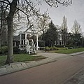
 's-Gravenweg 154 - Rotterdam - 20192033 - RCE.jpg 1,200 × 875; 195 KB
 Ophaalbruggetje overzicht - Kralingen - 20127590 - RCE.jpg 1,188 × 1,200; 399 KB
 Ophaalbruggetje overzicht - Kralingen - 20127591 - RCE.jpg 1,197 × 1,200; 424 KB
 Ophaalbruggetje overzicht - Kralingen - 20127592 - RCE.jpg 1,195 × 1,200; 413 KB
 Ophaalbruggetje overzicht - Kralingen - 20127593 - RCE.jpg 1,188 × 1,200; 432 KB
 Overzicht ophaalbrug - Rotterdam - 20377839 - RCE.jpg 1,200 × 1,200; 367 KB
 Rotterdam gravenweg154.jpg 2,481 × 1,917; 801 KB
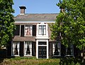
 Voorgevel - Kralingen - 20127588 - RCE.jpg 1,200 × 809; 320 KB


