Category:'s-Herenstraat 36, Maasland
Jump to navigation
Jump to search

| Object location | | View all coordinates using: OpenStreetMap - Google Earth - Proximityrama |
|---|
 | |||
| Upload media | |||
| Instance of | house | ||
|---|---|---|---|
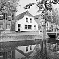
| Location | Maasland, South Holland, Netherlands | ||
| Street address |
| ||
| Heritage designation |
| ||

| |||
| |||
|
This is a category about rijksmonument number 26573 |
Address
| 's-Herenstraat 36 Maasland Netherlands |
Media in category "'s-Herenstraat 36, Maasland"
The following 5 files are in this category, out of 5 total.
 Maasland - 's Herenstraat 36.jpg 2,592 × 1,944; 1.47 MB
 Overzicht - Maasland - 20144562 - RCE.jpg 1,200 × 947; 232 KB
 Overzicht - Maasland - 20144633 - RCE.jpg 1,200 × 951; 260 KB
 Overzicht - Maasland - 20144635 - RCE.jpg 1,200 × 954; 241 KB
 Voorgevel - Maasland - 20144634 - RCE.jpg 1,200 × 1,197; 395 KB


