Category:'s Gravenhof 22, Zutphen
Jump to navigation
Jump to search

| Object location | | View all coordinates using: OpenStreetMap - Google Earth - Proximityrama |
|---|
 | |||
| Upload media | |||
| Instance of | building | ||
|---|---|---|---|
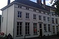
| Location | Zutphen, Gelderland, Netherlands | ||
| Street address |
| ||
| Heritage designation |
| ||

| |||
| |||
|
This is a category about rijksmonument number 41198 |
Address
| 's Gravenhof 22 7201 DN Zutphen Netherlands |
Media in category "'s Gravenhof 22, Zutphen"
The following 2 files are in this category, out of 2 total.
 Twee panden aan het 's-Gravenhof te Zutphen - Zutphen - 20227236 - RCE.jpg 1,200 × 804; 149 KB
 Zutphen - 's Gravenhof 22.jpg 2,592 × 1,728; 1.16 MB
