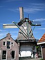
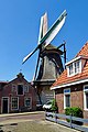
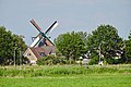
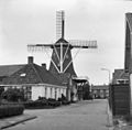
Category:'t Lam, Woudsend
Jump to navigation
Jump to search

| Object location | | View all coordinates using: OpenStreetMap - Google Earth - Proximityrama |
|---|
 | |||
| Upload media | |||
| Instance of | windmill, stellingmill, gristmill | ||
|---|---|---|---|
| Location | Woudsend, Friesland, Netherlands | ||
| Street address |
| ||
| Heritage designation |
| ||

| |||
| |||
|
This is a category about rijksmonument number 39846 |
Address
| Molestrjitte 4 Woudsend Netherlands |
Media in category "'t Lam, Woudsend"
The following 13 files are in this category, out of 13 total.
 't Lam molen Woudsend 04.JPG 2,304 × 3,072; 1.05 MB
 't Lam molen Woudsend 11.JPG 1,403 × 2,113; 385 KB
 't Lam molen Woudsend 13.JPG 2,039 × 3,060; 919 KB
 't Lam molen Woudsend 17.JPG 1,024 × 768; 112 KB
 't Lam molen Woudsend 23.JPG 3,072 × 2,304; 1.4 MB
 't Lam, Woudsend.JPG 4,608 × 3,456; 3.5 MB
 20190617 molen t Lam1 Woudsend.jpg 3,456 × 5,184; 3.04 MB
 20190617 zicht op Woudsend. met molen t Lam.jpg 5,184 × 3,456; 4.34 MB
 2720190617 molen t Lam2 Woudsend.jpg 3,278 × 4,917; 2.56 MB
 De Kamp - Woudsend - 20218137 - RCE.jpg 1,200 × 1,195; 366 KB
 Korenmolen Het Lam, overzicht - Woudsend - 20218210 - RCE.jpg 1,200 × 1,176; 212 KB
 Molenstrjitte - Woudsend - 20218154 - RCE.jpg 1,188 × 1,200; 316 KB
 Molenstrjitte - Woudsend - 20218155 - RCE.jpg 1,200 × 1,197; 323 KB


