Category:'t Loug 13, Spijk
Jump to navigation
Jump to search

| Object location | | View all coordinates using: OpenStreetMap - Google Earth - Proximityrama |
|---|
 | |||
| Upload media | |||
| Instance of | building | ||
|---|---|---|---|
| Location | Spijk, Groningen, Delfzijl, Groningen, Netherlands | ||
| Heritage designation |
| ||

| |||
| |||
|
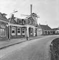
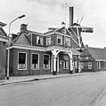
This is a category about rijksmonument number 9490 |
Address
| 't Loug 13 Spijk Netherlands |
Media in category "'t Loug 13, Spijk"
The following 6 files are in this category, out of 6 total.
 Exterieur GEDEELTE VAN DE VOORGEVEL - Spijk - 20291697 - RCE.jpg 1,190 × 1,200; 253 KB
 Exterieur VOORGEVEL - Spijk - 20291695 - RCE.jpg 1,192 × 1,200; 290 KB
 Exterieur VOORGEVEL - Spijk - 20291696 - RCE.jpg 1,192 × 1,200; 277 KB
 Spijk - 't Loug 13 - cafe.jpg 3,572 × 2,679; 3.58 MB
 Voorgevel - Spijk - 20203251 - RCE.jpg 1,188 × 1,200; 300 KB


