Category:Ben Nevis
Jump to navigation
Jump to search

|
Ben Nevis has an entry on OpenStreetMap (show). |
highest mountain of Great Britain  | |||
| Upload media | |||
| Instance of | mountain, tourist attraction | ||
|---|---|---|---|
| Material used | |||
| Location | Scottish Highlands, Highland, Kilmonivaig, United Kingdom | ||
| Mountain range | |||
| Topographic prominence |
| ||
| Elevation above sea level |
| ||
| official website | |||

| |||
| |||
Deutsch: Der Ben Nevis ( gäl. Beinn Nibheis ) ist mit einer Höhe von 1344 Metern der höchste Berg Schottlands und Großbritanniens. Er liegt im Westen Schottlands nahe der Stadt Fort William und zählt zu den 284 Munros.
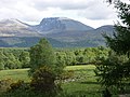
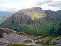
English: Ben Nevis is the highest mountain in the British Isles. It is located at the western end of the Grampian Mountains in the Lochaber area of the Scottish Highlands, close to the town of Fort William.
Español: Ben Nevis (en gaélico escocés Beinn Nibheis pronunciado ) es la mayor elevación del Reino Unido. Se localiza en el extremo occidental de los montes Grampianos en la región escocesa de Lochaber, cerca del pueblo costero de Fort William.
Euskara: Ben Nevis (Eskoziako gaeleraz Beinn Nibheis) Erresuma Batuko mendirik garaiena da. Granpian mendien mendebaldean kokatzen da, Eskoziako Lochaber eskualdean, kostaldeko Fort William udalerritik hurbil.
Français : Le Ben Nevis est le sommet le plus haut du Royaume-Uni avec 1344 m d'altitude. Situé près de Fort William en Écosse, il fait partie des monts Grampians (Grampian Mountains), chaîne de montagnes de moyenne altitude formant une séparation naturelle entre les Lowlands et les Highlands d'Écosse.
Gàidhlig: Is i Beinn Nibheis a' bheinn as àirde ann an Alba, aig 1344m (4409tr). Tha i suidhichte ann am Monadh Dhruim Uachdair os cionn Glinn Nibheis, faisg air a' Ghearasdan ann an Loch Abar.
Македонски: Бен Невис е највисока планина на Британски Острови. Сместена е на западниот крај на Грампијански Планини во подрачјето на Лохабер во Шкотските Гори, недалеку од населеното место Форт Вилијам.
Українська: Бен-Невіс — найвища гора Британських островів. Вона розташована на західному краю Грампіанських гір в районі Лохабер Шотландського Гайлендс, недалеко від містечка Форт-Вільям.
Subcategories
This category has the following 7 subcategories, out of 7 total.
A
B
H
Media in category "Ben Nevis"
The following 200 files are in this category, out of 301 total.
(previous page) (next page)_RMG_PZ4706.tiff/lossy-page1-120px-%27Ben_Nevis%2C_from_the_end_of_the_Caledonian_Canal%2C_1843%27_(Scotland)_RMG_PZ4706.tiff.jpg) 'Ben Nevis, from the end of the Caledonian Canal, 1843' (Scotland) RMG PZ4706.tiff 4,800 × 3,587; 49.26 MB
'Ben Nevis, from the end of the Caledonian Canal, 1843' (Scotland) RMG PZ4706.tiff 4,800 × 3,587; 49.26 MB
 'Staring into the abyss' - geograph.org.uk - 1588241.jpg 471 × 611; 118 KB
 A cairn near the summit of Ben Nevis - geograph.org.uk - 1106463.jpg 640 × 480; 94 KB
 A climber at the top of No5 Gully - geograph.org.uk - 1104545.jpg 640 × 480; 62 KB
 About half way there - geograph.org.uk - 1520318.jpg 640 × 426; 53 KB
 Allt a' Mhuilinn.JPG 1,024 × 768; 257 KB
 Aonach Beag.JPG 1,107 × 1,209; 423 KB
 Approaching a ford on the Ben Nevis path - geograph.org.uk - 856551.jpg 640 × 480; 401 KB
 Ascend of the Ben Nevis 03.jpg 3,264 × 1,840; 1.22 MB
 Ascend of the Ben Nevis 04.jpg 3,264 × 1,840; 1.31 MB
 Ascend of the Ben Nevis 05.jpg 3,264 × 1,840; 1.04 MB
 Banavie railway station 1750005 eba59859.jpg 640 × 394; 122 KB
.jpg/120px-Banavie_Station_(geograph_5324117).jpg) Banavie Station (geograph 5324117).jpg 1,800 × 1,013; 1.21 MB
Banavie Station (geograph 5324117).jpg 1,800 × 1,013; 1.21 MB
 Beach with a view - geograph.org.uk - 1343283.jpg 640 × 487; 76 KB
 Beinn Odhar - geograph.org.uk - 267226.jpg 640 × 446; 67 KB
 Ben N Face annotated.jpg 640 × 480; 121 KB
.jpg/90px-Ben_Nevis_(6631367871).jpg) Ben Nevis (6631367871).jpg 1,936 × 2,592; 1.65 MB
Ben Nevis (6631367871).jpg 1,936 × 2,592; 1.65 MB
 Ben Nevis , Munro No 1 - geograph.org.uk - 69846.jpg 640 × 480; 209 KB
 BEN NEVIS - Fort Augustus, Scotland - May 13, 1989 - panoramio.jpg 2,900 × 1,974; 1.79 MB
 Ben Nevis - Fort Augustus, Scotland, UK - May 13, 1989.jpg 2,500 × 1,783; 4.87 MB
 Ben Nevis - geograph.org.uk - 1025186.jpg 640 × 480; 80 KB
 Ben Nevis - geograph.org.uk - 1027451.jpg 640 × 480; 73 KB
 Ben Nevis - geograph.org.uk - 1053.jpg 440 × 640; 57 KB
 Ben Nevis - geograph.org.uk - 127894.jpg 451 × 640; 71 KB
 Ben Nevis - geograph.org.uk - 1342812.jpg 640 × 480; 37 KB
 Ben Nevis - geograph.org.uk - 22231.jpg 640 × 480; 84 KB
 Ben Nevis - geograph.org.uk - 273128.jpg 640 × 447; 77 KB
 Ben Nevis - geograph.org.uk - 592847.jpg 640 × 424; 62 KB
 Ben Nevis - geograph.org.uk - 592866.jpg 640 × 424; 70 KB
 Ben Nevis - geograph.org.uk - 596893.jpg 640 × 424; 76 KB
 Ben Nevis - geograph.org.uk - 614456.jpg 640 × 432; 109 KB
 Ben Nevis - geograph.org.uk - 714420.jpg 521 × 640; 37 KB
 Ben Nevis - geograph.org.uk - 95552.jpg 640 × 425; 40 KB
 Ben Nevis - geograph.org.uk - 96471.jpg 640 × 480; 92 KB
 Ben Nevis - Highland Aviation.jpg 4,032 × 3,024; 2.32 MB
 Ben Nevis - Panorama.jpg 11,800 × 3,558; 22.95 MB
.jpg/120px-Ben_Nevis_-_panoramio_-_Alistair_Cunningham_(1).jpg) Ben Nevis - panoramio - Alistair Cunningham (1).jpg 1,024 × 768; 358 KB
Ben Nevis - panoramio - Alistair Cunningham (1).jpg 1,024 × 768; 358 KB
 Ben Nevis - panoramio - Alistair Cunningham.jpg 1,024 × 768; 306 KB
 Ben Nevis - panoramio - Stuart Locke.jpg 2,816 × 2,112; 2.64 MB
 Ben Nevis - panoramio.jpg 1,024 × 768; 290 KB
 Ben Nevis Abendstimmung.JPG 2,910 × 1,940; 2.22 MB
 Ben Nevis and Carn Dearg - geograph.org.uk - 1520299.jpg 640 × 458; 43 KB
 Ben Nevis and Fort William from west.jpg 3,072 × 2,304; 2.61 MB
 Ben Nevis and Glen Coe, One-inch Ordnance Survey Tourist Map, Published 1959.jpg 9,630 × 12,446; 16.89 MB
 Ben Nevis April 2004 - geograph.org.uk - 585331.jpg 640 × 480; 26 KB
 Ben Nevis area on summer - panoramio.jpg 3,672 × 4,896; 8.19 MB
 Ben Nevis at sunset.jpg 1,280 × 583; 53 KB
 Ben Nevis cornice.jpg 630 × 448; 104 KB
 Ben Nevis footpath - geograph.org.uk - 992880.jpg 640 × 480; 51 KB
 Ben Nevis footpath near Auchintee - geograph.org.uk - 992872.jpg 640 × 480; 46 KB
 Ben Nevis from Aonach Mor - geograph.org.uk - 106378.jpg 640 × 440; 38 KB
 Ben Nevis from B8004 - geograph.org.uk - 14176.jpg 640 × 480; 140 KB
 Ben Nevis from Banavie - geograph.org.uk - 13749.jpg 640 × 480; 133 KB
 Ben Nevis from Ben Nevis lake - panoramio.jpg 4,000 × 3,000; 4.79 MB
 Ben Nevis from Corpach - geograph.org.uk - 1324605.jpg 429 × 640; 61 KB
 Ben Nevis from Corpach - geograph.org.uk - 747744.jpg 640 × 480; 48 KB
 Ben Nevis from Corpach sea lock - geograph.org.uk - 701632.jpg 480 × 640; 78 KB
 Ben Nevis from Corpach sea lock. - geograph.org.uk - 256874.jpg 640 × 480; 54 KB
 Ben Nevis from Fort William - panoramio.jpg 1,024 × 768; 223 KB
 Ben Nevis from Glen Coe - geograph.org.uk - 243136.jpg 640 × 427; 52 KB
 Ben Nevis from Loch Linnhe - geograph.org.uk - 38359.jpg 640 × 442; 80 KB
 Ben Nevis from Muirshearlich - geograph.org.uk - 14135.jpg 640 × 480; 141 KB
 Ben Nevis from near Mullach nan Coirean - geograph.org.uk - 565570.jpg 640 × 427; 208 KB
 Ben Nevis from near Torlundy - geograph.org.uk - 15304.jpg 640 × 466; 138 KB
 Ben Nevis from Spidean Mialach - geograph.org.uk - 98269.jpg 480 × 640; 66 KB
 Ben Nevis Highland Centre - geograph.org.uk - 877205.jpg 640 × 480; 58 KB
 Ben Nevis homepage.jpg 1,920 × 1,100; 368 KB
 Ben Nevis Inn at Auchintee - geograph.org.uk - 992871.jpg 640 × 480; 67 KB
.jpg/120px-Ben_Nevis_Looking_West_(NBY_441744).jpg) Ben Nevis Looking West (NBY 441744).jpg 3,600 × 2,347; 1.94 MB
Ben Nevis Looking West (NBY 441744).jpg 3,600 × 2,347; 1.94 MB
 Ben nevis mountain path.jpg 705 × 400; 105 KB
 Ben Nevis Mountain Track.jpg 4,208 × 2,748; 6.19 MB
 Ben Nevis North Face appears.jpg 1,024 × 768; 427 KB
 Ben Nevis northern approaches - geograph.org.uk - 585871.jpg 800 × 600; 233 KB
 Ben Nevis over the Caledonian Canal - geograph.org.uk - 1027434.jpg 640 × 480; 106 KB
 Ben Nevis panorama.jpg 7,580 × 1,986; 2.49 MB
 Ben Nevis path - geograph.org.uk - 856479.jpg 640 × 480; 342 KB
 Ben Nevis path - geograph.org.uk - 856944.jpg 640 × 480; 313 KB
 Ben Nevis path from the Glen road. - geograph.org.uk - 233970.jpg 640 × 480; 106 KB
.jpg/90px-Ben_Nevis_Pathwork_(2015).jpg) Ben Nevis Pathwork (2015).jpg 720 × 960; 131 KB
Ben Nevis Pathwork (2015).jpg 720 × 960; 131 KB
 Ben Nevis rescue of 3 climbers - geograph.org.uk - 95656.jpg 488 × 376; 30 KB
 Ben Nevis Scotland viewed from Aonach Mor - panoramio.jpg 1,600 × 769; 179 KB
 Ben Nevis side - geograph.org.uk - 856854.jpg 640 × 480; 331 KB
 Ben Nevis south face.jpg 640 × 480; 105 KB
 Ben Nevis Summit - geograph.org.uk - 1372100.jpg 640 × 480; 49 KB
 Ben Nevis Summit - geograph.org.uk - 64822.jpg 640 × 480; 59 KB
 Ben Nevis summit - north face - panoramio.jpg 768 × 1,024; 485 KB
 Ben Nevis Summit - panoramio.jpg 1,680 × 1,116; 501 KB
 Ben Nevis summit - west face - panoramio.jpg 768 × 1,024; 559 KB
.jpg/77px-Ben_Nevis_The_Summit_(NBY_441717).jpg) Ben Nevis The Summit (NBY 441717).jpg 2,330 × 3,600; 2.03 MB
Ben Nevis The Summit (NBY 441717).jpg 2,330 × 3,600; 2.03 MB
 Ben Nevis to Loch Linnhe panorama.jpg 10,000 × 3,066; 12.34 MB
 Ben Nevis to Stob Ban and Glen Coe.jpg 3,827 × 2,776; 3.59 MB
 Ben nevis tough.jpg 640 × 480; 61 KB
 Ben Nevis Tourist Route.jpg 714 × 800; 87 KB
 Ben Nevis trig - geograph.org.uk - 154011.jpg 640 × 360; 29 KB
 Ben Nevis Trig Point - geograph.org.uk - 1106511.jpg 640 × 480; 29 KB
 Ben Nevis wv.jpg 2,592 × 1,944; 920 KB
_(9461805777).jpg/76px-Ben_Nevis%2C_Fort_William_(250321)_(9461805777).jpg) Ben Nevis, Fort William (250321) (9461805777).jpg 2,658 × 4,184; 2.97 MB
Ben Nevis, Fort William (250321) (9461805777).jpg 2,658 × 4,184; 2.97 MB
 Ben Nevis, Fort William - panoramio.jpg 1,301 × 2,048; 921 KB
_(9461646695).jpg/120px-Ben_Nevis%2C_Lochaber_(200601)_(9461646695).jpg) Ben Nevis, Lochaber (200601) (9461646695).jpg 4,132 × 2,638; 2.39 MB
Ben Nevis, Lochaber (200601) (9461646695).jpg 4,132 × 2,638; 2.39 MB
_(9461652725).jpg/120px-Ben_Nevis%2C_Lochaber_(200602)_(9461652725).jpg) Ben Nevis, Lochaber (200602) (9461652725).jpg 4,426 × 2,762; 3.33 MB
Ben Nevis, Lochaber (200602) (9461652725).jpg 4,426 × 2,762; 3.33 MB
.jpg/120px-Ben_Nevis%2C_Lochaber_-_panoramio_(1).jpg) Ben Nevis, Lochaber - panoramio (1).jpg 2,048 × 1,278; 663 KB
Ben Nevis, Lochaber - panoramio (1).jpg 2,048 × 1,278; 663 KB
 Ben Nevis, Lochaber - panoramio.jpg 2,048 × 1,308; 656 KB
 Ben Nevis. From FWVL.jpg 4,320 × 3,240; 3.07 MB
 Ben Nevis.jpg 640 × 480; 62 KB
 Ben nevis.jpg 800 × 343; 189 KB
 Ben Nevis.JPG 1,728 × 2,304; 1.04 MB
 Ben Nevis2.JPG 1,728 × 2,304; 1.34 MB
 Bend in Nevis path - geograph.org.uk - 856624.jpg 640 × 480; 332 KB
 Bend in the path to Ben Nevis - geograph.org.uk - 856447.jpg 640 × 480; 302 KB
 BenNevis2005.jpg 2,048 × 1,536; 432 KB
 BenNevisSummit.JPG 2,592 × 1,944; 1.92 MB
.jpg/120px-Binnein_Mor_and_Na_Gruagaichean_-_27AUG2014_25_(15228637822).jpg) Binnein Mor and Na Gruagaichean - 27AUG2014 25 (15228637822).jpg 3,088 × 2,056; 2.27 MB
Binnein Mor and Na Gruagaichean - 27AUG2014 25 (15228637822).jpg 3,088 × 2,056; 2.27 MB
.jpg/120px-Binnein_Mor_and_Na_Gruagaichean_-_27AUG2014_26_(15225907021).jpg) Binnein Mor and Na Gruagaichean - 27AUG2014 26 (15225907021).jpg 3,088 × 2,056; 2.07 MB
Binnein Mor and Na Gruagaichean - 27AUG2014 26 (15225907021).jpg 3,088 × 2,056; 2.07 MB
.jpg/120px-Binnein_Mor_and_Na_Gruagaichean_-_27AUG2014_40_(15042197859).jpg) Binnein Mor and Na Gruagaichean - 27AUG2014 40 (15042197859).jpg 3,088 × 2,056; 2.21 MB
Binnein Mor and Na Gruagaichean - 27AUG2014 40 (15042197859).jpg 3,088 × 2,056; 2.21 MB
_-_geograph.org.uk_-_1419715.jpg/120px-Britain%27s_highest_war_memorial_(2)_-_geograph.org.uk_-_1419715.jpg) Britain's highest war memorial (2) - geograph.org.uk - 1419715.jpg 640 × 480; 90 KB
Britain's highest war memorial (2) - geograph.org.uk - 1419715.jpg 640 × 480; 90 KB
 Britain's highest War Memorial - geograph.org.uk - 1000771.jpg 640 × 480; 115 KB
 Cairn ben nevis.jpg 610 × 400; 54 KB
 Cairn near Ben Nevis summit - geograph.org.uk - 856969.jpg 640 × 480; 239 KB
 Cairn near Ben Nevis summit - geograph.org.uk - 857053.jpg 640 × 480; 322 KB
 Carn Dearg - geograph.org.uk - 227992.jpg 640 × 427; 93 KB
 Carn Mor Dearg and Ben Nevis - geograph.org.uk - 68281.jpg 640 × 480; 95 KB
_4x3.jpg/120px-Carn_Mor_Dearg_Arete_from_CMD_summit_(Lochaber%2C_Scotland)_4x3.jpg) Carn Mor Dearg Arete from CMD summit (Lochaber, Scotland) 4x3.jpg 400 × 300; 95 KB
Carn Mor Dearg Arete from CMD summit (Lochaber, Scotland) 4x3.jpg 400 × 300; 95 KB
_4x3.jpg/120px-Castle_Corrie_and_Castle_Ridge_(Ben_Nevis%2C_Highland_Scotland)_4x3.jpg) Castle Corrie and Castle Ridge (Ben Nevis, Highland Scotland) 4x3.jpg 468 × 351; 149 KB
Castle Corrie and Castle Ridge (Ben Nevis, Highland Scotland) 4x3.jpg 468 × 351; 149 KB
 CIC hut Ben Nevis - geograph.org.uk - 1155127.jpg 640 × 480; 77 KB
 Climbing Ben Nevis footpath - geograph.org.uk - 992882.jpg 640 × 480; 52 KB
 Climbing Carn Dearg Meadhonach - geograph.org.uk - 1469697.jpg 480 × 640; 88 KB
.jpg/120px-Cloudy_highlands_(Unsplash).jpg) Cloudy highlands (Unsplash).jpg 5,184 × 3,456; 8.81 MB
Cloudy highlands (Unsplash).jpg 5,184 × 3,456; 8.81 MB
_from_CIC_hut_4x3.jpg/120px-Coire_na_Ciste_(Ben_Nevis%2C_Highland_Scotland)_from_CIC_hut_4x3.jpg) Coire na Ciste (Ben Nevis, Highland Scotland) from CIC hut 4x3.jpg 468 × 351; 141 KB
Coire na Ciste (Ben Nevis, Highland Scotland) from CIC hut 4x3.jpg 468 × 351; 141 KB
 Commando Memorial and Ben Nevis.jpg 4,252 × 2,848; 3.62 MB
 Continuing path to Ben Nevis summit - geograph.org.uk - 856583.jpg 640 × 480; 343 KB
 Continuing path to Ben Nevis summit - geograph.org.uk - 856762.jpg 640 × 480; 336 KB
 Cornice on Ben Nevis summit - geograph.org.uk - 1381026.jpg 640 × 480; 34 KB
 Corpach Harbour - geograph.org.uk - 887073.jpg 640 × 416; 66 KB
 Corpach Sea lock. - geograph.org.uk - 256872.jpg 640 × 480; 89 KB
 Crags and Cornices - geograph.org.uk - 1582507.jpg 640 × 416; 91 KB
 Crags on Ben Nevis - geograph.org.uk - 1660142.jpg 640 × 418; 69 KB
 Descent of the Ben Nevis 07.jpg 3,264 × 1,840; 1.12 MB
 Escape route to Coire Leis - geograph.org.uk - 1469699.jpg 480 × 640; 43 KB
 First Snow On The Summit - panoramio.jpg 1,146 × 1,662; 369 KB
 Fort William and Ben Nevis - geograph.org.uk - 1025208.jpg 640 × 480; 79 KB
 Fort William and Ben Nevis, Scotland LOC 3449526567.jpg 1,024 × 764; 171 KB
 Fort William new station geograph-3526325-by-Ben-Brooksbank.jpg 2,395 × 1,473; 3.11 MB
 Gift, Just No Poison - panoramio.jpg 1,600 × 1,200; 1.09 MB
 Glen Chia-aig. - geograph.org.uk - 68248.jpg 640 × 466; 32 KB
 Glen Nevis - Flickr - Graham Grinner Lewis.jpg 3,648 × 2,736; 2.57 MB
.jpg/120px-Glen_Nevis_-_panoramio_(1).jpg) Glen Nevis - panoramio (1).jpg 4,288 × 2,848; 6.84 MB
Glen Nevis - panoramio (1).jpg 4,288 × 2,848; 6.84 MB
 Hard way to climb - panoramio.jpg 1,698 × 1,116; 391 KB
 Heading for Ben Nevis - geograph.org.uk - 598346.jpg 640 × 430; 54 KB
 Helicopter Drop - Ben Nevis Pathwork 2015.jpg 563 × 563; 234 KB
 Highland, UK - panoramio.jpg 2,048 × 1,536; 1.58 MB
_4x3.jpg/120px-Ledge_Route_from_Tower_Ridge_(Ben_Nevis%2C_Scotland)_4x3.jpg) Ledge Route from Tower Ridge (Ben Nevis, Scotland) 4x3.jpg 400 × 300; 93 KB
Ledge Route from Tower Ridge (Ben Nevis, Scotland) 4x3.jpg 400 × 300; 93 KB
 Ledge Route on Ben Nevis - geograph.org.uk - 955777.jpg 418 × 640; 127 KB
 Loch Linnhe near Fort William.jpg 3,951 × 2,688; 4.36 MB
 Loch Meall an T-Suidhe - panoramio.jpg 1,686 × 1,110; 451 KB
 Lochan Lunn Da-Bhra and Loch Linnhe from Ben Nevis.jpg 3,652 × 2,692; 3.24 MB
 Lochan Meall an t-Suidhe.jpg 4,023 × 2,684; 4.62 MB
 Lochan meall an t-suidhe.jpg 597 × 400; 91 KB
 Looking back along the Ben Nevis path - geograph.org.uk - 856977.jpg 640 × 480; 248 KB
 Looking down on the Ben Nevis path - geograph.org.uk - 856515.jpg 640 × 480; 352 KB
 Looking North-Northwest from Ben Nevis - geograph.org.uk - 856937.jpg 640 × 480; 312 KB
 Looking to the Ben Nevis summit - geograph.org.uk - 856925.jpg 640 × 480; 366 KB
 Looking to the summit of Ben Nevis - geograph.org.uk - 856802.jpg 640 × 480; 301 KB
 Lorn and Lochaber.jpg 9,805 × 11,882; 59.41 MB
 Lower slopes of Creag Ghorm - geograph.org.uk - 1800716.jpg 800 × 600; 142 KB
_Station_(geograph_5330552).jpg/120px-Mallaig_bound_service_arriving_at_Loch_Eil_(Outward_Bound)_Station_(geograph_5330552).jpg) Mallaig bound service arriving at Loch Eil (Outward Bound) Station (geograph 5330552).jpg 1,800 × 1,012; 1.73 MB
Mallaig bound service arriving at Loch Eil (Outward Bound) Station (geograph 5330552).jpg 1,800 × 1,012; 1.73 MB
 Mount Ben Nevis.jpg 640 × 480; 308 KB
 Mountain Stream - geograph.org.uk - 103996.jpg 640 × 474; 44 KB
 Mullach nan Coirean - geograph.org.uk - 238823.jpg 640 × 480; 151 KB
 Near Ben Nevis.jpg 1,600 × 1,200; 841 KB
 Near the madding crowd - geograph.org.uk - 1345457.jpg 640 × 480; 77 KB
 Nevis path getting busier - geograph.org.uk - 856604.jpg 640 × 480; 355 KB
 No 2 gully.jpg 625 × 400; 66 KB
 No 5 Gully Ben Nevis - geograph.org.uk - 1104496.jpg 640 × 480; 87 KB


.jpg)


.jpg)


.jpg)


.jpg)


.jpg)


.jpg)


.jpg)


_(9461805777).jpg)

_(9461646695).jpg)
_(9461652725).jpg)
.jpg)


.jpg)
.jpg)
.jpg)
_-_geograph.org.uk_-_1419715.jpg)


_on_Ben_Nevis_looking_northwards_-_geograph.org.uk_-_791168.jpg)


_4x3.jpg)
_4x3.jpg)


.jpg)
_from_CIC_hut_4x3.jpg)


_and_East_Gully_in_May_2014_with_cloud_in_background_and_a_few_snowpatches.jpg)
_and_Raeburn%27s_Arete_(behind,_left)_4x3.jpg)


.jpg)


.jpg)


_4x3.jpg)


_Station_(geograph_5330552).jpg)

_3x4.JPG)


Categories:
- Grampians
- Munros
- Marilyns of Scotland
- Mountains and hills of the Central Highlands
- National Scenic Areas in Scotland
- Sites of Special Scientific Interest in Highland council area
- Special Areas of Conservation in Scotland
- Volcanoes of Scotland
- 1340s mountains
- County tops of the United Kingdom
- Andesite formations in Scotland