Category:Château de Drée
Jump to navigation
Jump to search

| Object location | | View all coordinates using: OpenStreetMap - Google Earth - Proximityrama |
|---|
|
This building is inscrit au titre des Monuments Historiques. It is indexed in the Base Mérimée, a database of architectural heritage maintained by the French Ministry of Culture, under the reference PA00113261
|
 | |||
| Upload media | |||
| Instance of | castle | ||
|---|---|---|---|
| Location | Curbigny, canton of Clayette, arrondissement of Charolles, Saône-et-Loire, Bourgogne-Franche-Comté, France | ||
| Heritage designation |
| ||

| |||
| |||
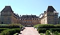
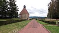
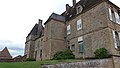
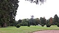
English: The 17th century Château de Drée and Baroque gardens, in Curbigny Saône-et-Loire, Burgundy—Bourgogne, France.
Français : Château de Drée et jardin, Curbigny.
Media in category "Château de Drée"
The following 72 files are in this category, out of 72 total.
 Chateau de Dree 20.jpg 2,302 × 1,726; 2.16 MB
 Chateau de Dree 4.jpg 2,216 × 1,294; 1.26 MB
_-_1.JPG/90px-Château_de_Drée_(71)_-_1.JPG) Château de Drée (71) - 1.JPG 2,736 × 3,648; 2.32 MB
Château de Drée (71) - 1.JPG 2,736 × 3,648; 2.32 MB
 Château de Drée - Allée principale.jpg 4,128 × 2,322; 4.23 MB
 Château de Drée - Allée.jpg 4,128 × 2,322; 4.12 MB
 Château de Drée - Angle de la cour.jpg 4,128 × 2,322; 4.03 MB
 Château de Drée - Bassin du jardin des topiaires.jpg 4,128 × 2,322; 2.9 MB
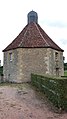
 Château de Drée - Boucherie.jpg 4,128 × 2,322; 2.16 MB
 Château de Drée - Bâtiment et puits.jpg 4,128 × 2,322; 3.19 MB
 Château de Drée - Chenil.jpg 4,128 × 2,322; 3.28 MB
 Château de Drée - Cognassier de la roseraie.jpg 4,128 × 2,322; 4.21 MB
 Château de Drée - Colombier - nids.jpg 2,322 × 4,128; 2.8 MB
 Château de Drée - Colombier - plateforme.jpg 4,128 × 2,322; 2.99 MB
 Château de Drée - Colombier.jpg 4,128 × 2,322; 3.67 MB
 Château de Drée - Colonne 2.jpg 2,322 × 4,128; 4.4 MB
 Château de Drée - Colonne 3.jpg 2,322 × 4,128; 4.35 MB
 Château de Drée - Colonne 4.jpg 2,322 × 4,128; 4.15 MB
 Château de Drée - Colonne 5.jpg 2,322 × 4,128; 2.78 MB
 Château de Drée - Colonne.jpg 2,322 × 4,128; 2.94 MB
 Château de Drée - Cour.jpg 4,128 × 2,322; 3.47 MB
 Château de Drée - Côté est.jpg 4,128 × 2,322; 3.63 MB
 Château de Drée - Côté nord.jpg 4,128 × 2,322; 3.15 MB
 Château de Drée - Côté ouest.jpg 4,128 × 2,322; 3.05 MB
 Château de Drée - Dépendance nord.jpg 4,128 × 2,322; 3.4 MB
 Château de Drée - Dépendance sud et grille.jpg 4,128 × 2,322; 3.64 MB
 Château de Drée - Dépendance.jpg 4,128 × 2,322; 3.23 MB
 Château de Drée - Dépendances sud.jpg 4,128 × 2,322; 4.33 MB
 Château de Drée - Dépendances, prison et colombier.jpg 4,128 × 2,322; 3.17 MB
 Château de Drée - Détail.jpg 2,322 × 4,128; 4.38 MB
 Château de Drée - Entrée.jpg 4,128 × 2,322; 3.28 MB
 Château de Drée - Escalier ouest et statue.jpg 2,322 × 4,128; 4.93 MB
 Château de Drée - Extérieur.jpg 4,128 × 2,322; 2.97 MB
 Château de Drée - Façade ouest et broderies de buis.jpg 4,128 × 2,322; 4.06 MB
 Château de Drée - Fond de la glacière.jpg 2,322 × 4,128; 2.7 MB
 Château de Drée - Fontaine de la roseraie.jpg 4,128 × 2,322; 3.54 MB
 Château de Drée - Grand bassin.jpg 4,128 × 2,322; 4.63 MB
 Château de Drée - Grille.jpg 4,128 × 2,322; 3.14 MB
 Château de Drée - Jardin de buis côté nord.jpg 4,128 × 2,322; 4.67 MB
 Château de Drée - Jardin de buis côté sud.jpg 4,128 × 2,322; 5.01 MB
 Château de Drée - Jardin des topiaires - If et champignons.jpg 4,128 × 2,322; 4.62 MB
 Château de Drée - Jardin des topiaires 2.jpg 4,128 × 2,322; 2.79 MB
 Château de Drée - Jardin des topiaires 3.jpg 4,128 × 2,322; 2.97 MB
 Château de Drée - Jardin des topiaires.jpg 4,128 × 2,322; 2.74 MB
 Château de Drée - Jardin, dépendance sud et prison.jpg 4,128 × 2,322; 4.03 MB
 Château de Drée - Lampisterie.jpg 4,128 × 2,322; 2.49 MB
 Château de Drée - Mur et bâtiment.jpg 4,128 × 2,322; 4.06 MB
 Château de Drée - Mur.jpg 4,128 × 2,322; 5.52 MB
 Château de Drée - Passage.jpg 2,322 × 4,128; 2.01 MB
 Château de Drée - Plafond de la prison.jpg 4,128 × 2,322; 2.71 MB
 Château de Drée - Portail de la roseraie.jpg 4,128 × 2,322; 3.1 MB
 Château de Drée - Porte d'entrée de la glacière.jpg 4,128 × 2,322; 4.22 MB
 Château de Drée - Poulailler.jpg 4,128 × 2,322; 2.57 MB
 Château de Drée - Prison 2.jpg 2,322 × 4,128; 3.84 MB
 Château de Drée - Prison.jpg 2,322 × 4,128; 2.82 MB
 Château de Drée - Roseraie - fontaine et serre.jpg 4,128 × 2,322; 4.43 MB
 Château de Drée - Roseraie 2.jpg 4,128 × 2,322; 2.91 MB
 Château de Drée - Roseraie.jpg 4,128 × 2,322; 3.11 MB
 Château de Drée - Serre.jpg 4,128 × 2,322; 3.85 MB
 Château de Drée - Sortie de la prison.jpg 2,322 × 4,128; 2.48 MB
 Château de Drée - Statue du jardin de buis.jpg 4,128 × 2,322; 3.32 MB
 Château de Drée - Statues de la fontaine de la roseraie.jpg 4,128 × 2,322; 4.48 MB
 Château de Drée - Tour des demoiselles - Intérieur.jpg 2,322 × 4,128; 2.75 MB
 Château de Drée - Tour des demoiselles 2.jpg 2,322 × 4,128; 4.41 MB
 Château de Drée - Tour des demoiselles 3.jpg 4,128 × 2,322; 4.21 MB
 Château de Drée - Tour des demoiselles.jpg 2,322 × 4,128; 4.3 MB
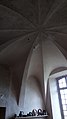 Château de Drée - Voûte en parapluie de la boucherie.jpg 2,322 × 4,128; 2.2 MB
 Château de Drée - Vue depuis la roseraie.jpg 4,128 × 2,322; 3 MB
 Château de Drée - Vue par la fenêtre est.jpg 2,322 × 4,128; 3.27 MB
 Château de Drée - Vue sur la glacière.jpg 2,322 × 4,128; 2.74 MB
 Château de Drée - Étables.jpg 2,322 × 4,128; 2.45 MB
 Château de Drée-1.JPG 4,608 × 3,456; 4.2 MB
 Château de Drée-2.JPG 4,608 × 3,456; 4.33 MB


_-_1.JPG)


