Category:Maps of Crimean War
Jump to navigation
Jump to search

Wikimedia category | |||
| Upload media | |||
| Instance of | Wikimedia category | ||
|---|---|---|---|
| Category combines topics | map, Crimean War | ||
| Crimean War | |||
military conflict fought between October 1853 – March 1856  | |||
| Instance of | war | ||
| Part of | Ottoman wars in Europe, History of the Russo-Turkish wars | ||
| Location | Crimean Peninsula, Caucasus, Balkans, Black Sea, Baltic Sea, White Sea, Kamchatka Peninsula | ||
| Start time | October 1853 | ||
| End time | February 1856 | ||
| |||
Media in category "Maps of Crimean War"
The following 81 files are in this category, out of 81 total.
.jpg/120px-10_of_%27A_visit_to_the_Camp_before_Sebastopol%27_(11045865226).jpg) 10 of 'A visit to the Camp before Sebastopol' (11045865226).jpg 2,624 × 2,010; 1.13 MB
10 of 'A visit to the Camp before Sebastopol' (11045865226).jpg 2,624 × 2,010; 1.13 MB
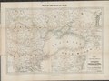 1854 Map of the frontier provinces of Turkey, Russia & Austria, the Black Sea, &c.tif 8,044 × 5,964; 137.28 MB
 Guerre d'Orient, la Crimée.jpg 5,137 × 3,647; 3.04 MB
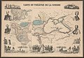 1855 map - Carte du Théâtre de la Guerre.jpg 10,800 × 7,500; 24.31 MB
 1856 Sevastopol.png 4,451 × 4,974; 50.44 MB
.jpg/120px-487_of_%27The_Illustrated_History_of_the_War_against_Russia._Plates%27_(11045661606).jpg) 487 of 'The Illustrated History of the War against Russia. Plates' (11045661606).jpg 2,880 × 1,879; 1.14 MB
487 of 'The Illustrated History of the War against Russia. Plates' (11045661606).jpg 2,880 × 1,879; 1.14 MB
.jpg/82px-518_of_%27The_Illustrated_History_of_the_War_against_Russia._Plates%27_(11047239356).jpg) 518 of 'The Illustrated History of the War against Russia. Plates' (11047239356).jpg 1,897 × 2,764; 1.19 MB
518 of 'The Illustrated History of the War against Russia. Plates' (11047239356).jpg 1,897 × 2,764; 1.19 MB
.jpg/81px-519_of_%27The_Illustrated_History_of_the_War_against_Russia._Plates%27_(11045726023).jpg) 519 of 'The Illustrated History of the War against Russia. Plates' (11045726023).jpg 1,871 × 2,763; 1.15 MB
519 of 'The Illustrated History of the War against Russia. Plates' (11045726023).jpg 1,871 × 2,763; 1.15 MB
.jpg/120px-805_of_%27The_Illustrated_History_of_the_War_against_Russia._Plates%27_(11046475014).jpg) 805 of 'The Illustrated History of the War against Russia. Plates' (11046475014).jpg 2,768 × 1,867; 994 KB
805 of 'The Illustrated History of the War against Russia. Plates' (11046475014).jpg 2,768 × 1,867; 994 KB
 Battaglia di Balaclava.svg 744 × 538; 119 KB
.jpg/120px-Battle_at_Akhaltsikhe_(scheme%2C_1853).jpg) Battle at Akhaltsikhe (scheme, 1853).jpg 1,000 × 922; 165 KB
Battle at Akhaltsikhe (scheme, 1853).jpg 1,000 × 922; 165 KB
.jpg/120px-Battle_of_Atskuri_1853_(plan).jpg) Battle of Atskuri 1853 (plan).jpg 900 × 893; 172 KB
Battle of Atskuri 1853 (plan).jpg 900 × 893; 172 KB
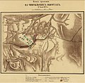
.jpg/120px-Battle_of_Balaklava_(Bogdanovich_1876).jpg) Battle of Balaklava (Bogdanovich 1876).jpg 3,140 × 2,718; 2.16 MB
Battle of Balaklava (Bogdanovich 1876).jpg 3,140 × 2,718; 2.16 MB
.jpg/108px-Battle_of_Inkerman_(Bogdanovich_1876).jpg) Battle of Inkerman (Bogdanovich 1876).jpg 1,877 × 2,093; 1.06 MB
Battle of Inkerman (Bogdanovich 1876).jpg 1,877 × 2,093; 1.06 MB
.jpg/118px-Battle_of_Inkerman_(Dubrovin_1872).jpg) Battle of Inkerman (Dubrovin 1872).jpg 1,677 × 1,710; 679 KB
Battle of Inkerman (Dubrovin 1872).jpg 1,677 × 1,710; 679 KB
 Battle of Malakoff map fr.svg 7,312 × 4,887; 1.62 MB
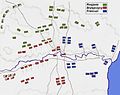
.jpg/120px-Battle_of_the_Alma_(Bogdanovich_1876).jpg) Battle of the Alma (Bogdanovich 1876).jpg 1,796 × 1,408; 520 KB
Battle of the Alma (Bogdanovich 1876).jpg 1,796 × 1,408; 520 KB
.jpg/120px-Battle_of_the_Alma_(Dubrovin_1871).jpg) Battle of the Alma (Dubrovin 1871).jpg 1,748 × 1,444; 623 KB
Battle of the Alma (Dubrovin 1871).jpg 1,748 × 1,444; 623 KB
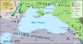
 Black sea crimean war.jpg 1,674 × 1,023; 478 KB
 Carpathians to Dnieper.jpg 1,880 × 1,393; 1.13 MB
 Crimean war map 1853-06-es.svg 1,618 × 861; 1.48 MB
 Crimean war map 1853-06.svg 1,618 × 861; 957 KB
 Crimean war map 1853-10-es.svg 1,618 × 861; 1.49 MB
 Crimean war map 1853-10.svg 1,618 × 861; 969 KB
 Crimean war map 1853-12-es.svg 1,618 × 861; 1.57 MB
 Crimean war map 1853-12.svg 1,618 × 861; 995 KB
 Crimean war map 1854-06-es.svg 1,618 × 861; 1.51 MB
 Crimean war map 1854-06.svg 1,618 × 861; 966 KB
 Crimean war map 1854-09-es.svg 1,618 × 861; 1.57 MB
 Crimean war map 1854-09.svg 1,618 × 861; 990 KB
 Crimean war map 1854-11-es.svg 1,618 × 861; 1.51 MB
 Crimean war map 1854-11.svg 1,618 × 861; 975 KB
 Crimean war map 1855-06-es.svg 1,618 × 861; 1.5 MB
 Crimean war map 1855-06.svg 1,618 × 861; 973 KB
 Crimean war map 1855-11-es.svg 1,618 × 861; 1.55 MB
 Crimean war map 1855-11.svg 1,618 × 861; 988 KB
 Crimean war map-fr.svg 980 × 538; 851 KB
 Crimean-war-1853-56-legend.png 1,736 × 855; 49 KB
 Crimean-war-1853-56.png 2,167 × 1,191; 165 KB
_b_467.jpg/112px-Die_Gartenlaube_(1853)_b_467.jpg) Die Gartenlaube (1853) b 467.jpg 2,444 × 2,622; 2.77 MB
Die Gartenlaube (1853) b 467.jpg 2,444 × 2,622; 2.77 MB
_b_600.jpg/120px-Die_Gartenlaube_(1854)_b_600.jpg) Die Gartenlaube (1854) b 600.jpg 2,825 × 1,905; 1.63 MB
Die Gartenlaube (1854) b 600.jpg 2,825 × 1,905; 1.63 MB
_b_345.jpg/120px-Die_Gartenlaube_(1855)_b_345.jpg) Die Gartenlaube (1855) b 345.jpg 825 × 532; 64 KB
Die Gartenlaube (1855) b 345.jpg 825 × 532; 64 KB
_b_518.jpg/120px-Die_Gartenlaube_(1855)_b_518.jpg) Die Gartenlaube (1855) b 518.jpg 1,007 × 785; 630 KB
Die Gartenlaube (1855) b 518.jpg 1,007 × 785; 630 KB
 Die-festungswerke-sebastopols-während-der-belagerung.jpg 2,712 × 1,864; 1.75 MB
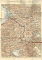
 EB1911 Crimean War - Seat of Crimean War.jpg 862 × 990; 396 KB
 EB1911 Crimean War - Sevastopol 1854-1856.jpg 861 × 742; 303 KB
 Linguistic map of Eastern Europe, Max Müller, 1854.jpg 3,913 × 2,954; 3.4 MB
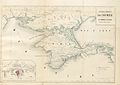
 Maclure, Macdonald & Macgregor's map of the Black Sea, Krimea, & Danubian principalities, &c.tif 13,270 × 9,516; 361.31 MB
.jpg/92px-Map_of_a_fortress_of_Kars_during_the_Crimean_War_1853-1855_(Bogdanovich_1876).jpg) Map of a fortress of Kars during the Crimean War 1853-1855 (Bogdanovich 1876).jpg 3,075 × 3,995; 2.52 MB
Map of a fortress of Kars during the Crimean War 1853-1855 (Bogdanovich 1876).jpg 3,075 × 3,995; 2.52 MB
 Map of port of Balaklava and route to Sevastopol 1855.png 1,999 × 1,547; 6.95 MB
 Map of Sebastopol lines 1855.png 2,204 × 1,669; 8.1 MB
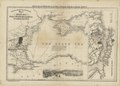
 Map of the campaigns in Asiatic Turkey in 1853-55.jpg 2,000 × 2,841; 692 KB
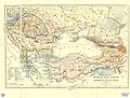
.jpg/85px-Map_of_the_Caucasus_War_Area_during_the_Crimean_War_1853-1855_(Bogdanovich_1876).jpg) Map of the Caucasus War Area during the Crimean War 1853-1855 (Bogdanovich 1876).jpg 2,819 × 3,984; 2.87 MB
Map of the Caucasus War Area during the Crimean War 1853-1855 (Bogdanovich 1876).jpg 2,819 × 3,984; 2.87 MB
 Mapa bitwy nad Almą.JPG 2,027 × 1,601; 270 KB
 Osadnye raboty Sevastopolya 1854-55.jpg 9,510 × 7,077; 35.84 MB
 Petropavlovsk 1854.png 850 × 493; 31 KB
.jpg/120px-Plan_of_a_fortress_of_Sevastopol_during_the_Crimean_War_1853-1855_(Rerberg_1903).jpg) Plan of a fortress of Sevastopol during the Crimean War 1853-1855 (Rerberg 1903).jpg 1,966 × 1,318; 885 KB
Plan of a fortress of Sevastopol during the Crimean War 1853-1855 (Rerberg 1903).jpg 1,966 × 1,318; 885 KB
 SeacoleWar.png 1,188 × 956; 137 KB
 Sewastopol 1854 2.jpg 1,517 × 861; 610 KB
 Siege of Sevastopol map1 es.svg 4,733 × 3,375; 2.14 MB
 Siege of Sevastopol map1 fr.svg 4,733 × 3,375; 1.32 MB
 Siege of Sevastopol map2 es.svg 5,059 × 3,620; 2 MB
 Siege of Sevastopol map2 fr.svg 5,059 × 3,620; 972 KB
 Sir John Hall's papers; map of Turkey Wellcome L0026305.jpg 1,280 × 1,618; 1.07 MB
 Sir T. Longmore's papers, Crimean War; winter 1855-6 Wellcome L0025765.jpg 1,152 × 1,784; 836 KB
 The Armenian Front During the Crimean War, 1853-56.gif 700 × 407; 47 KB
.jpg/120px-Карта_к_статье_«Инкерман»._Военная_энциклопедия_Сытина_(Санкт-Петербург%2C_1911-1915).jpg) Карта к статье «Инкерман». Военная энциклопедия Сытина (Санкт-Петербург, 1911-1915).jpg 2,012 × 1,904; 1.02 MB
Карта к статье «Инкерман». Военная энциклопедия Сытина (Санкт-Петербург, 1911-1915).jpg 2,012 × 1,904; 1.02 MB
 План крепости Силестрии в 1854.png 2,449 × 1,765; 3.1 MB
 План осады Силистрии в 1854.JPG 9,070 × 7,106; 10.7 MB
 План сражения на реке Чолок.jpg 1,280 × 919; 259 KB
 План сражения на Чингильских высотах.jpg 982 × 966; 432 KB
.jpg)
%27_(11232818726).jpg)
%27_(11233767783).jpg)
%27_(11059952056).jpg)


.jpg)
.jpg)
.jpg)
.jpg)

.jpg)
.jpg)
.jpg)
.jpg)
.jpg)

.jpg)
.jpg)


_b_467.jpg)
_b_600.jpg)
_b_345.jpg)
_b_518.jpg)


,_RP-P-2018-1158.jpg)
.jpg)

.jpg)


.jpg)


.jpg)


.jpg)
.jpg)
.jpg)
.jpg)
.jpg)


