Category:Mount Scenery
Jump to navigation
Jump to search

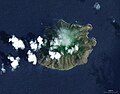
potentially active volcano on Saba, the Caribbean Netherlands  | |||
| Upload media | |||
| Instance of | mountain, stratovolcano, potentially active volcano | ||
|---|---|---|---|
| Part of | Lesser Antilles | ||
| Material used | |||
| Location | Saba, Netherlands | ||
| Located on terrain feature | Saba | ||
| Topographic prominence |
| ||
| Elevation above sea level |
| ||

| |||
| |||
Media in category "Mount Scenery"
The following 16 files are in this category, out of 16 total.
.jpg/120px-Almost_to_the_top%21_(6562062273).jpg) Almost to the top! (6562062273).jpg 3,264 × 2,448; 3.53 MB
Almost to the top! (6562062273).jpg 3,264 × 2,448; 3.53 MB
 Cloud Winning over Saba.jpg 1,024 × 768; 139 KB
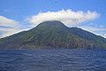
 Mount Scenery.jpg 2,613 × 3,269; 3.92 MB
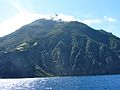
 Mt. Scenery from sea.JPG 2,304 × 1,536; 1.7 MB
 Mt. Scenery from Windwardside.JPG 2,304 × 1,536; 1.73 MB
 Narrow Streets of Windwardside.jpg 1,024 × 768; 222 KB
 Saba Morning Haze.jpg 1,600 × 1,200; 533 KB
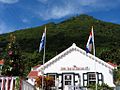 Saba Tourist Bureau with Mount Scenery Peak in Backdrop.jpg 1,024 × 768; 193 KB
 Saba Weg zum Mount Scenery.jpg 640 × 982; 255 KB
 Saba with cloud cover.jpg 1,590 × 1,030; 1.5 MB
 Saba World Wind.jpg 1,036 × 809; 196 KB
.jpg/120px-Tower_at_Top_of_Mount_Scenery_(6550016077).jpg) Tower at Top of Mount Scenery (6550016077).jpg 1,024 × 768; 229 KB
Tower at Top of Mount Scenery (6550016077).jpg 1,024 × 768; 229 KB
 View over Windwardside and Mt Scenery, Saba.jpg 3,024 × 1,998; 2.21 MB
 Windwardside Village with Mount Scenery.jpg 768 × 1,024; 281 KB
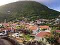 Windwardside.jpg 3,264 × 2,448; 3.8 MB
.jpg)


.jpg)


