Category:Rhine Basin
Jump to navigation
Jump to search

drainage basin in Western Europe | |||
| Upload media | |||
| Instance of | drainage basin | ||
|---|---|---|---|
| Named after | |||
| Location | Austria, Belgium, France, Germany, Italy, Liechtenstein, Luxembourg, Netherlands, Switzerland | ||
| Located in or next to body of water | Rhine | ||
| Has part |
| ||
| Mouth of the watercourse | |||
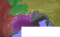
| Drainage basin |
| ||
| |||
Subcategories
This category has the following 65 subcategories, out of 65 total.
2
A
B
C
D
E
F
G
H
L
M
N
P
Q
R
S
T
U
V
W
Y
Z
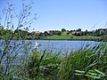
Media in category "Rhine Basin"
The following 32 files are in this category, out of 32 total.
 Abriss ORG.jpg 1,543 × 1,151; 404 KB
 Alps orographic.png 600 × 371; 262 KB
 Bodenehr schiltach.jpg 2,783 × 2,057; 1.52 MB
 Buers-Schlucht Konglomerat.JPG 2,048 × 1,536; 724 KB
.jpg/120px-Churches_in_Lorch_(Rheingau).jpg) Churches in Lorch (Rheingau).jpg 2,883 × 2,162; 2.08 MB
Churches in Lorch (Rheingau).jpg 2,883 × 2,162; 2.08 MB
 D-BW-Neukirch - Jaegerweiher abgelassen.jpg 2,816 × 2,112; 3.55 MB
 D-BW-Tettnang - Muttelsee II.JPG 2,592 × 1,944; 1.34 MB
 D-BW-Tettnang - Muttelsee.JPG 2,592 × 1,944; 1.83 MB
 Fermasee.jpg 700 × 524; 86 KB
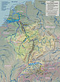
 Flusssystemkarte Rhein 01.svg 861 × 1,186; 7.81 MB
 Flusssystemkarte Rhein 02.jpg 3,197 × 4,342; 11.75 MB
 Flusssystemkarte Rhein 03.jpg 3,198 × 4,342; 11.75 MB
 Flusssystemkarte Rhein 04.jpg 3,198 × 4,344; 11.72 MB
 Flusssystemkarte Rhein 05.jpg 3,199 × 4,341; 12.35 MB
 Flusssystemkarte Rhein 06.jpg 3,198 × 4,343; 11.74 MB
 Kestert Rheinschleife 2015-06-07 13.38.21.jpg 2,337 × 2,298; 4.36 MB
 Kestert081110.JPG 4,000 × 3,000; 7.63 MB
 Map of the Electorate of Trier and other Rhineland states. 1685.jpg 1,815 × 1,542; 3.96 MB
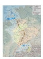
 Map Rhine and catchment area deutsch.jpg 2,132 × 2,891; 2.86 MB
 Plan d'eau de plobsheim.png 1,442 × 902; 1.77 MB
 Rheinsystem blanco.jpg 3,196 × 4,342; 10.46 MB
 Rheinsystem small blanco.jpg 2,133 × 2,889; 2.19 MB
 Rheinsystem small deutsch.jpg 2,133 × 2,885; 2.8 MB
 Rheinsystem small english.jpg 2,133 × 2,888; 2.85 MB
 Rheinsystem small francais.jpg 2,133 × 2,888; 2.86 MB
 Rheinsystem small internat.jpg 2,133 × 2,890; 2.87 MB
 Rheinsystem small nederlands.jpg 2,133 × 2,885; 2.85 MB
 Spruner-Menke Handatlas 1880 Karte 44 Nebenkarte 1.jpg 1,633 × 3,419; 536 KB
 Swist.JPG 1,632 × 1,224; 1.08 MB
 Verlaufskarte Schwarzbach.png 1,280 × 1,280; 359 KB
 Water divide Rhine Weser.png 937 × 791; 204 KB


_(6797620822).jpg)
.jpg)


