File:1855 Colton Map of Turkey, Iraq, and Syria - Geographicus - TurkeyIraq-colton-1855.jpg
Original file (3,500 × 3,034 pixels, file size: 3.22 MB, MIME type: image/jpeg)
Captions
Captions
| J. H. Colton: Turkey in Asia and the Caucasian Provinces of Russia | |||||||||||||||||||||
|---|---|---|---|---|---|---|---|---|---|---|---|---|---|---|---|---|---|---|---|---|---|
| Artist |
|
||||||||||||||||||||
| Title |
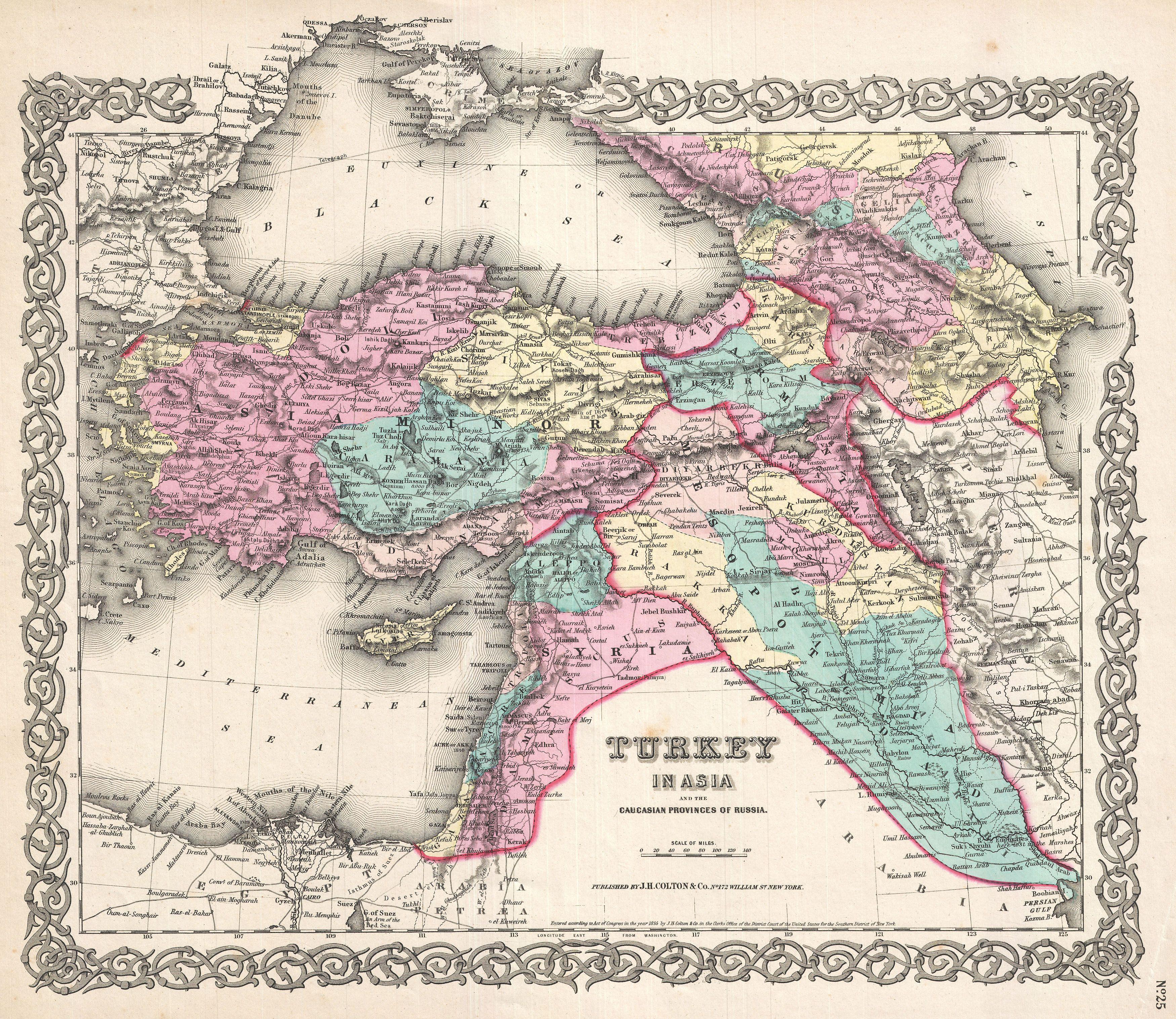
Turkey in Asia and the Caucasian Provinces of Russia
|
||||||||||||||||||||
| Description |
العربية: خريطة جميلة لِإيالات الدولة العُثمانيَّة في آسيا وتظهر فيها المُقاطعات القوقازيَّة التي تُسيطر عليها روسيا. تعود هذه الخريطة لِلطبعة الأولى لِأطلس كولتون الصادر سنة 1855م.
English: A beautiful 1855 first edition example of Colton's map of the Ottoman Empire (Turkey) in Asia and the Caucuses.
|
||||||||||||||||||||
| Date | 1855 (dated) | ||||||||||||||||||||
| Dimensions | Height: 13 in (33 cm); Width: 16.5 in (41.9 cm) | ||||||||||||||||||||
| Accession number |
Geographicus link: TurkeyIraq-colton-1855 |
||||||||||||||||||||
| Source/Photographer |
Colton, G. W., Colton's Atlas of the World Illustrating Physical and Political Geography, Vol 2, New York, 1855 (First Edition).
|
||||||||||||||||||||
| Permission (Reusing this file) |
|
||||||||||||||||||||

|
File history
Click on a date/time to view the file as it appeared at that time.
| Date/Time | Thumbnail | Dimensions | User | Comment | |
|---|---|---|---|---|---|
| current | 15:33, 23 March 2011 | | 3,500 × 3,034 (3.22 MB) | BotMultichillT (talk | contribs) | {{subst:User:Multichill/Geographicus |link=http://www.geographicus.com/P/AntiqueMap/TurkeyIraq-colton-1855 |product_name=1855 Colton Map of Turkey, Iraq, and Syria |map_title=Turkey in Asia and the Caucasian Provinces of Russia. |description=A beautiful 1 |
You cannot overwrite this file.
File usage on Commons
The following page uses this file:
File usage on other wikis
The following other wikis use this file:
- Usage on ar.wikipedia.org
- الأقاليم السورية الشمالية
- إيالة عثمانية
- إيالة صيدا
- بوابة:الدولة العثمانية/صورة
- مستخدم:عمرو بن كلثوم/الأقاليم السورية الشمالية
- ويكيبيديا:صور مختارة/رسومات وجداول وخرائط/خرائط
- قائمة إيالات الدولة العثمانية
- ويكيبيديا:ترشيحات الصور المختارة/الإيالات العثمانية الآسيوية
- ويكيبيديا:صورة اليوم المختارة/أغسطس 2017
- قالب:صورة اليوم المختارة/2017-08-11
- بوابة:الدولة العثمانية/صورة مختارة/35
- ويكيبيديا:صورة اليوم المختارة/يناير 2020
- قالب:صورة اليوم المختارة/2020-01-14
- Usage on az.wikipedia.org
- Usage on bn.wikipedia.org
- Usage on ckb.wikipedia.org
- Usage on en.wikipedia.org
- Usage on et.wikipedia.org
- Usage on fa.wikipedia.org
- Usage on it.wikipedia.org
- Usage on ko.wikipedia.org
- Usage on ku.wikipedia.org
- Usage on pnb.wikipedia.org
- Usage on ro.wikipedia.org
- Usage on tr.wikipedia.org
- Usage on ur.wikipedia.org
- Usage on zh.wikipedia.org
Structured data
- Maps by Joseph Hutchins Colton
- 1855 maps of the Ottoman Empire
- Maps of the Ottoman Empire in the 19th century
- Ottoman Empire in the 1850s
- Maps of eyalets of the Ottoman Empire
- Old Administrative Maps of the Ottoman Empire
- Maps of the Ottoman Levant
- Old maps of the Caucasus
- Old maps of the Middle East
- Old maps showing the whole Near East
- 1855 maps of Georgia
- 1855 maps of Armenia
- Armenia in the 1850s
- 1855 maps of Azerbaijan
- 1855 maps of Turkey
- 1855 maps of Syria
- 1855 maps of Iraq
- 1855 maps of Israel
- 1859 in Ottoman Palestine
- Israel in the 1850s
- 1855 maps of Palestine
- 1855 maps of Cyprus
- 1855 maps of Jordan
- 19th-century maps of the Black Sea
- 1855 maps of Egypt
- Old maps of Nile Delta
- 19th century maps of the Middle East
- Cavad (Sabirabad)