File:2009-05-12 Zeyar 01.jpg
Original file (6,112 × 1,943 pixels, file size: 4.75 MB, MIME type: image/jpeg)
Captions
Description2009-05-12 Zeyar 01.jpg |
Iran, Road from Tehran to the Caspian Sea near Zeyar |
||
Date | |||
Source |
Own work of Simisa (talk · contribs)
|
||
Author | Hansueli Krapf | ||
Permission (Reusing this file) |
Attribution ShareAlike 3.0 |
Camera location | 35° 51′ 17.83″ N, 52° 04′ 37.88″ E | View this and other nearby images on: OpenStreetMap - Google Earth | 35.854953; 52.077190 |
---|
|
This file is licensed under the Creative Commons Attribution-Share Alike 3.0 Unported license. | |
https://creativecommons.org/licenses/by-sa/3.0 CC BY-SA 3.0 Creative Commons Attribution-Share Alike 3.0 truetrue |
File history
Click on a date/time to view the file as it appeared at that time.
Date/Time | Thumbnail | Dimensions | User | Comment | |
---|---|---|---|---|---|
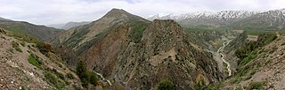
current | 12:23, 12 July 2009 | 6,112 × 1,943 (4.75 MB) | Simisa (talk | contribs) | {{Information |Description={{IRN}}, Road from Tehran to the Caspian Sea near Zeyar |Source={{Own}} of {{User|Simisa}} {{Panorama|category=}} |Date=see metadata |Author=Hansueli Krapf |Permission=Attribution ShareAlike 3.0 |other_versions= |
You cannot overwrite this file.
File usage on Commons
There are no pages that use this file.
File usage on other wikis
The following other wikis use this file:
- Usage on fa.wikipedia.org
Metadata
This file contains additional information such as Exif metadata which may have been added by the digital camera, scanner, or software program used to create or digitize it. If the file has been modified from its original state, some details such as the timestamp may not fully reflect those of the original file. The timestamp is only as accurate as the clock in the camera, and it may be completely wrong.
Camera manufacturer | NIKON |
---|---|
Camera model | E8800 |
Exposure time | 1/280 sec (0.0035714285714286) |
F-number | f/6.3 |
ISO speed rating | 50 |
Date and time of data generation | 08:46, 12 May 2009 |
Lens focal length | 8.9 mm |
Horizontal resolution | 300 dpi |
Vertical resolution | 300 dpi |
Software used | Picasa 3.0 |
File change date and time | 08:46, 12 May 2009 |
Y and C positioning | Co-sited |
Exposure Program | Normal program |
Exif version | 2.2 |
Date and time of digitizing | 08:46, 12 May 2009 |
Meaning of each component |
|
Image compression mode | 7 |
APEX exposure bias | 0 |
Maximum land aperture | 3.1 APEX (f/2.93) |
Metering mode | Pattern |
Light source | Unknown |
Flash | Flash did not fire, compulsory flash suppression |
Supported Flashpix version | 0,100 |
Color space | Uncalibrated |
File source | Digital still camera |
Scene type | A directly photographed image |
Unique image ID | a8726beb57c64ec5ae18573780fea99a |
Latitude | 35° 51′ 17.83″ N |
Longitude | 52° 4′ 37.88″ E |
Altitude | 2,394 meters above sea level |
GPS tag version | 2.2.0.0 |
Sublocation of city shown | Zeyar |
Province or state shown | Mazandaran Province |
Code for country shown | IRN |
Country shown | Iran |
Keywords |
|
- Featured pictures on Wikipedia, Persian
- Files with Assessments template missing SDC Commons quality assessment
- Pages with local camera coordinates and missing SDC coordinates
- CC-BY-SA-3.0
- Creative Commons Attribution-Share Alike 3.0 Unported missing SDC copyright license
- Files by User:simisa
- Pages with maps