File:Alsace Lorraine departments evolution map-en.svg
Jump to navigation
Jump to search


Size of this PNG preview of this SVG file: 600 × 450 pixels. Other resolutions: 320 × 240 pixels | 640 × 480 pixels | 800 × 600 pixels | 1,024 × 768 pixels | 1,280 × 960 pixels.
Original file (SVG file, nominally 600 × 450 pixels, file size: 91 KB)
Captions
Add a one-line explanation of what this file represents
Captions
Summary[edit]
| Description |
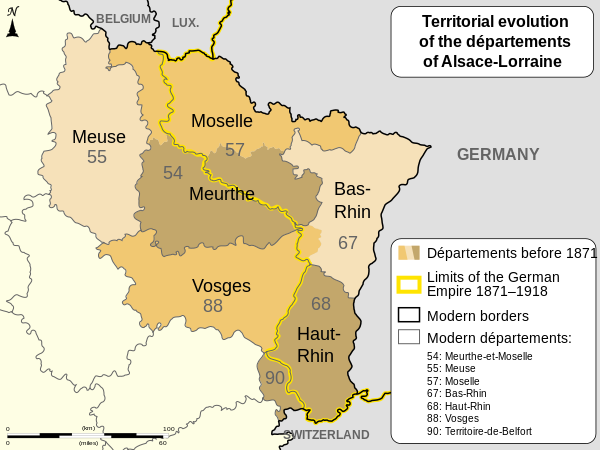
English: Changes of the boundaries of departments in Alsace and Lorraine before and after the German Empire's rule (1871-1918). Français : Évolution territoriale des départements de l'Alsace et de la Lorraine avant et après l'Empire allemand (1871-1918). |
| Date | (UTC) |
| Source | |
| Author |
|
| Other versions |
[]
|


| Camera location | | View this and other nearby images on: OpenStreetMap - Google Earth |
|---|
| This SVG file contains embedded text that can be translated into your language, using the SVG Translate tool or any capable SVG editor. For more information see: About translating SVG files. |
| This W3C-unspecified vector image was created with Inkscape.. |
Licensing[edit]
I, the copyright holder of this work, hereby publish it under the following licenses:
| Copyleft: This work of art is free; you can redistribute it and/or modify it according to terms of the Free Art License. You will find a specimen of this license on the Copyleft Attitude site as well as on other sites. |
|
This file is licensed under the Creative Commons Attribution-Share Alike 4.0 International, 3.0 Unported, 2.5 Generic, 2.0 Generic and 1.0 Generic license. | |
|
You may select the license of your choice.
Original upload log[edit]
This image is a derivative work of the following images:
- File:Alsace_Lorraine_departments_evolution_map-fr.svg licensed with Cc-by-sa-3.0,2.5,2.0,1.0, FAL
- 2010-12-27T08:17:38Z Sémhur 600x450 (100001 Bytes) Mistake (Moselle) : 56 => 57
- 2010-12-23T17:48:20Z Sémhur 600x450 (100022 Bytes) == {{int:filedesc}} == {{Information |Description={{Multilingual description |en= Boundaries evolution of [[:en:Alsace-Lorraine|Alsace and Lorraine]]'s departments before and after [[:en:German Empire|German Empire]] (1871-19
Uploaded with derivativeFX
File history
Click on a date/time to view the file as it appeared at that time.
| Date/Time | Thumbnail | Dimensions | User | Comment | |
|---|---|---|---|---|---|
| current | 19:47, 27 August 2011 | | 600 × 450 (91 KB) | OwenBlacker (talk | contribs) | == {{int:filedesc}} == {{Information |Description={{Multilingual description |en= Changes of the boundaries of departments in Alsace and Lorraine before and after the German Empire's rule (1871-1918). |fr= Év |
You cannot overwrite this file.
File usage on Commons
The following 10 pages use this file:
- User:M0tty/WWI
- File:Alsace Lorraine departments evolution map-cs.svg
- File:Alsace Lorraine departments evolution map-de.svg
- File:Alsace Lorraine departments evolution map-en.svg
- File:Alsace Lorraine departments evolution map-es.svg
- File:Alsace Lorraine departments evolution map-fr.svg
- File:Alsace Lorraine departments evolution map-hu.svg
- File:Alsace Lorraine departments evolution map-lb.svg
- File:Alsace Lorraine departments evolution map (en).svg (file redirect)
- Template:Other versions/Alsace Lorraine departments evolution map
.svg&redirect=no)
File usage on other wikis
The following other wikis use this file:
- Usage on ar.wikipedia.org
- Usage on az.wikipedia.org
- Usage on en.wikipedia.org
- Usage on ru.wikipedia.org