Category:Abbaye de Cerisy-la-Forêt
Jump to navigation
Jump to search

| Object location | | View all coordinates using: OpenStreetMap - Google Earth - Proximityrama |
|---|
|
This building is classé au titre des Monuments Historiques. It is indexed in the Base Mérimée, a database of architectural heritage maintained by the French Ministry of Culture, under the reference PA00110359
|
abbey located in Manche, in France  | |||
| Upload media | |||
| Instance of | abbey | ||
|---|---|---|---|
| Location | Cerisy-la-Forêt, canton of Saint-Clair-sur-l'Elle, arrondissement of Saint-Lô, Manche, Normandy, France | ||
| Architectural style | |||
| Diocese | |||
| Headquarters location | |||
| Has part | |||
| Founded by | |||
| Heritage designation |
| ||
| Inception |
| ||
| Religion | |||
| official website | |||

| |||
| |||
Subcategories
This category has the following 4 subcategories, out of 4 total.
A
C
Media in category "Abbaye de Cerisy-la-Forêt"
The following 48 files are in this category, out of 48 total.
 Abbaye 1 Cerisy-La-Forêt.jpg 1,716 × 2,576; 950 KB
 Abbaye Cerisy-La-Forêt.jpg 1,920 × 1,280; 526 KB
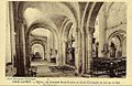
.png/120px-Abbaye_de_Cerisy-la-Forêt_(Par_Paul_de_Farcy).png) Abbaye de Cerisy-la-Forêt (Par Paul de Farcy).png 870 × 693; 719 KB
Abbaye de Cerisy-la-Forêt (Par Paul de Farcy).png 870 × 693; 719 KB
 Abbaye de Cerisy-la-Forêt 002.JPG 3,648 × 2,736; 1.89 MB
 Abbaye de Cerisy-la-Forêt 010.JPG 3,648 × 2,736; 1.84 MB
 Abbaye de Cerisy-la-Forêt 011.JPG 2,736 × 3,648; 2.55 MB
 Abbaye de Cerisy-la-Forêt 012.JPG 3,648 × 2,736; 1.85 MB
 Abbaye de Cerisy-la-Forêt 013.JPG 3,648 × 2,736; 1.58 MB
 Abbaye de Cerisy-la-Forêt 014.JPG 3,648 × 2,736; 1.79 MB
 Abbaye de Cerisy-la-Forêt Août 2009 a.jpg 1,167 × 1,490; 1.81 MB
 Abbaye de Cerisy-la-Forêt Août 2009 b.jpg 1,567 × 1,111; 2.28 MB
 Abbaye de Cerisy-la-Forêt chapelle 001.JPG 2,736 × 3,648; 2.76 MB
 Abbaye de Cerisy-la-Forêt entrée 1.JPG 3,124 × 2,554; 1.8 MB
 Abbaye de Cerisy-la-Forêt etang 001.JPG 3,648 × 2,736; 1.75 MB
 Abbaye de Cerisy-la-Forêt etang 002.JPG 3,648 × 2,736; 1.77 MB
 Abbaye de Cerisy-la-Forêt loggia 1.JPG 2,736 × 3,648; 2.57 MB
 Abbaye de Cerisy-la-Forêt loggia 2.JPG 2,736 × 3,648; 1.77 MB
 Abbaye de Cerisy-la-Forêt meule.JPG 3,648 × 2,736; 1.9 MB
 Abbaye de Cerisy-la-Forêt porche 001.JPG 3,648 × 2,736; 1.86 MB
 Abbaye de Cerisy-la-Forêt salle de justice.JPG 3,648 × 2,736; 1.87 MB
 Abbaye Saint-Vigor de Cerisy - Pierres en Lumières 2015.JPG 3,456 × 5,184; 9.28 MB
 Affichage abbaye.jpg 185 × 256; 10 KB
 Ancienneabbaye.jpg 256 × 162; 11 KB
 Blason fr Abbaye de Cerisy.svg 600 × 660; 23 KB
 Blasonvieuxabbaye.jpg 256 × 162; 7 KB
 Capelle de cerisy.JPG 3,648 × 2,736; 2.46 MB
 CerisyAbbaye 03.jpg 5,446 × 3,630; 16.54 MB
 CerisyAbbaye 07.jpg 5,889 × 3,926; 16.68 MB
 CerisyAbbaye 12.jpg 5,568 × 3,717; 12.77 MB
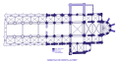 CerisyForetPlan.png 4,777 × 2,509; 851 KB
 Chapelle saint gerbold1.JPG 3,648 × 2,736; 2.45 MB
 Chapellestnicolas.jpg 256 × 166; 11 KB
 Dessin-de-henri-javalet.jpg 569 × 395; 75 KB
 Détail porche gothique abbaye de Cerisy.JPG 2,448 × 3,264; 1.29 MB
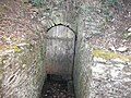 Entrée des souterrains de l'abbaye de Cerisy.JPG 3,648 × 2,736; 2.53 MB
 Escalier de l'abbaye de Cerisy.JPG 3,648 × 2,736; 4.65 MB
 Fenêtre de l'abbatiale de Cerisy.JPG 2,736 × 3,648; 4.42 MB
 Mur de Cerisy.JPG 3,648 × 2,736; 2.48 MB
 Mur de labbaye.JPG 2,736 × 3,648; 2.48 MB
 Musée Lapidaire de l'Abbaye de Cerisy-La-Forêt.jpg 3,456 × 2,304; 1.24 MB
 Plan de l'abbaye de Cerisy-la-Forêt.JPG 3,648 × 2,736; 4.66 MB
 Porche d'entrée de l'abbaye de Cerisy.JPG 3,648 × 2,736; 2.48 MB
 Porche de l'abbaye de Cerisy.JPG 2,448 × 3,264; 1.1 MB
 Porche gothique abbaye de Cerisy.JPG 2,448 × 3,264; 1.28 MB
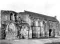 Ruines de l'abbaye de cerisy 2.jpg 697 × 512; 82 KB
 Ruines de l'abbaye de cerisy 3.jpg 696 × 512; 76 KB
 Ruines de l'abbaye de cerisy.jpg 800 × 588; 127 KB
 Vue de l'abbaye de Cerisy.JPG 3,264 × 2,448; 820 KB


.png)


