File:Mapa.Otto Hauser.PNG
Jump to navigation
Jump to search


Size of this preview: 571 × 599 pixels. Other resolutions: 229 × 240 pixels | 458 × 480 pixels | 572 × 600 pixels | 816 × 856 pixels.
Original file (816 × 856 pixels, file size: 1.7 MB, MIME type: image/png)
Captions
Add a one-line explanation of what this file represents
Captions
Summary[edit]
| Description |
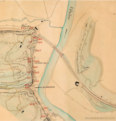
Deutsch: Übersichtsplan der prähistorischen Fundstätten No. 1-41 und Font de Gaume in der Umgebung von Les Eyzies im Tale der Vézère.
Aufgenommen und gezeichnet von April 1907 – Mai 1908 von Th. Baumgartner, Ingenieur u. Konkordatsgeometer Seebach-Zürich Scalebar = 220 m |
| Date | |
| Source | https://openaccess.leidenuniv.nl/bitstream/handle/1887/32983/APL41_01%20_Roebroeks%20et%20al.pdf?sequence=6 |
| Author | Otto Hauser |
Licensing[edit]
|
This work is in the public domain in its country of origin and other countries and areas where the copyright term is the author's life plus 70 years or fewer. This work is in the public domain in the United States because it was published (or registered with the U.S. Copyright Office) before January 1, 1925. | |
| This file has been identified as being free of known restrictions under copyright law, including all related and neighboring rights. | |
File history
Click on a date/time to view the file as it appeared at that time.
| Date/Time | Thumbnail | Dimensions | User | Comment | |
|---|---|---|---|---|---|
| current | 15:25, 2 January 2016 | | 816 × 856 (1.7 MB) | Nachosan (talk | contribs) | User created page with UploadWizard |
You cannot overwrite this file.
File usage on Commons
The following page uses this file:
File usage on other wikis
The following other wikis use this file:
- Usage on es.wikipedia.org